
CASTRO MARIM
N 37º 13' 07"; W 7º 26 '45"
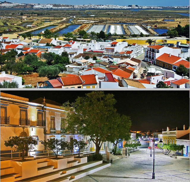
Leaning against a height that dominates the low marshy plain of Guadiana, near its mouth in the Gulf of Cadiz, Castro Marim occupies a strong position, facing the Spanish town of Ayamonte.
The marshes are classified as Castro Marim Nature Reserve.
The city already existed in Roman times. It became, in 1321, during the dissolution of the Templar order in Portugal, the seat of the Knights of Christ, before its transfer to Tomar in 1334. The ruins of its castle in red sandstone, demolished by the earthquake dating from 1755, rise to the north of the town, while the remains of the fort of Saint-Sébastien (seventeenth century) crown a hill to the south.


💓💓💓💓💓

AYAMONTE (SPAIN)
37°12′49″N 7°24′11″W
Ayamonte is a Spanish city and municipality located in the province of Huelva, Andalusia, situated next to the mouth of the Guadiana River, on the border with Portugal. With a population of 21,645 inhabitants (2023), an area of 141.29 km², and a population density of 145.27 inhabitants/km², it is the capital of the region of the Western Coast of Huelva. It is located 41 km from Huelva, the provincial capital, and 127 km from Seville, the regional capital.
Its origins date back to the Phoenician era, having been a settlement site for Romans, Arabs, Portuguese and Castilians. Starting in the 16th century, the city became one of the most important commercial and political points in the province, also benefiting from important commercial and economic relations with the Spanish colonies in America.
Currently, the traditional fishing and canning sector, the economic engine of the area in the 20th century, has given way to the development of other economic sectors in the town, mainly the tourism sector, making the municipality a prominent tourist destination in Andalusia. both for the beaches of Isla Canela, and for the important monumental and historical heritage existing in the city, as well as for the proximity of the Portuguese Algarve, with which Ayamonte is connected by the Guadiana International Bridge.
Human environment
The municipality consists of several population centers differentiated from each other. The most populated of them, and which gives its name to the entire municipality, is the center of Ayamonte itself, located on the banks of the Guadiana River, in front of the Portuguese town of Castromarín. This population center, in turn, is made up of different neighborhoods, the oldest of which, and the seed of the town, is the Villa neighborhood, where the city arose as a result of the location of the castle. Likewise, we can describe the also historic Ribera neighborhood as the center of the city, as the main economic, commercial and administrative services are located there. On the other hand, there are neighborhoods that emerged in the 20th century such as "Federico Mayo" or the Salón de Santa Gadea neighborhood, an authentic expansion of the town built in the second half of the 20th century with a layout of large avenues located in an environment surrounded of marshes and channels of the Guadiana River estuary.
On the other hand, we find other population centers, such as Punta del Moral, a district of Ayamonte located in the eastern area of Isla Canela, and very close in distance to the neighboring municipality of Isla Cristina, with great importance for the tertiary sector given the great importance economic and labor impact that sun and beach tourism acquires in summer times in the coastal areas of the municipality. Also on the island of Canela, there is the "Barriada de Canela", very close to the main center of Ayamonte, only separated from it by an arm of the river.
Finally, about 7 km from the main population center, Pozo del Camino is constituted as a district located on the border of the municipalities of Ayamonte and Isla Cristina, each of these municipalities administering the part that corresponds to them. In addition, Ayamonte is the head of the homonymous judicial district of the province of Huelva,10 which includes the municipalities of Isla Cristina, Lepe, Cartaya, Villablanca, San Silvestre de Guzmán and Sanlúcar de Guadiana.
Natural environment
Given its location in the estuary of the Guadiana River, we could highlight the surroundings of the mouth as a place. In the north it has a steeper orography but it quickly softens and loses relief, forming a flat terrain in its closest part to the ocean. From the highest part of the municipality, where the castle ruins were located, you can easily see the municipality of Isla Cristina, as well as the cities and towns of nearby Portugal.
The municipality of Ayamonte accompanies the river on its left bank, with the cities of Villarreal de San Antonio and Castromarín on the Portuguese shore, the former sharing the aforementioned mouth. Next to an abundant forest mass, formed mainly by stone pines and eucalyptus, are joined by some marshes that almost surround the town and which the settlers once used in different ways and forms. These marshes, called "zaperas", have great biodiversity, with some native species on the verge of extinction. The marshes form "caños", which are small natural channels that run through them and, winding, surround Ayamonte, forming a dense network. Much of the territory covered by marshes constitutes the Isla Cristina Marismas Natural Area, a space protected by the Junta de Andalucía for its high biological value, which extends from Ayamonte to the aforementioned island municipality.
Finally, mention should be made of the beaches of Isla Canela and the Punta del Moral neighborhood, open crescent-shaped beaches, also surrounded by marshes.
Climate
Ayamonte's climate is classified as warm and temperate. The influence of the sea acts as a temperature buffer on the climate in Ayamonte. Temperatures are mild in winter and hot in summer. The maximum averages for the month of August are 29.6 °C, only exceeding 35 °C occasionally. Humidity is the most pronounced meteorological characteristic of the municipality, normally reaching humidity levels greater than 100% in winter, which means that the humidity of the air coming from the coast and the marshes condenses in the air, giving rise to a typical phenomenon of area. The average annual temperature is 17.5 °C, with average total rainfall of 482 mm.


💓💓💓💓💓
SEARCH IN ALPHABETICAL ORDER
IN THE DISTRICT OF FARO
💓💓💓💓💓
Return to mainland Portugal &
the Azores and Madeira islands

