
MEXILHOEIRA GRANDE
37.158° N; 8.614° W
Mexilhoeira Grande is a civil parish in the municipality (concelho) of Portimão in the southern Portuguese region of the Algarve. The population in 2021 was 4,313, in an area of 91.15 km².
Geography
Mexilhoeira Grande is situated in the north of the municipality of Portimão, primarily encompassing rural lands comprising white-painted homes, traditionally agricultural.
It is bordered in the north by Monchique, by Portimão in the east, Alvor to the south, and by the parishes of Odiáxere, Bensafrim and Marmelete, in the north and northwest, respectively.
Economy
The region's economy is primarily agricultural-based, although tourism has an important influence on local revenues. The Autódromo Internacional do Algarve, is the natural gateway to the region; situated in an area of plains, approximately 6 kilometers (3.7 mi) to the north of the parish, it is interconnected by variants of the Estrada Nacional EN125.
Architecture
Prehistoric
Megalithic Monuments of Alcalar (Monumentos de Alcalar/Conjunto Pré-histórico de Alcalar/Povoado Calcolítico de Alcalar/Necrópole Megalítica de Alcalar), likely constructed between in the third millennium BCE and 1600 BCE, at the height of the Chalcolithic, consisting of several burial mounds/tombs, that were later acquired by the State, with formal excavations beginning at the end of the 20th century;
Archaeological
Roman ruins of Quinta da Abicada (Estação Romana da Quinta da Abicada, from excavations carried out by José Leite de Vasconcelos (1917) and José Formosinho Sanches (1938), it was determined that this Roman center dates back to the 1st century;
Civic
The Railway Station of Mexilhoeira Grande (Estação Ferroviária da Mexilhoeira Grande), constructed at the turn-of-the-century, of the railway station is a typical design for the period, but was redesigned to act as the Centro de Interpretação Ambiental da Ria de Alvor (The Environmental Interpretative Centre for the Alvor River);
Religious
Chapel of Nossa Senhora dos Passos (Capela da Senhora dos Passos/Capela de Nosso Senhor dos Passos) is a Baroque-era chapel with Neo-classical lines, the small temple consists of a space with a simple vaulted ceiling, with many 19th century decorations, including tympanum in the principal portico and neoclassical retable;
Church of Figueira (Igreja da Figueira)
Church of the Misericórdia (Igreja da Misericórdia), the single-nave 15th-century church, was founded after the establishment of the Misericórdia, the local benevolent and social society;
Church of Nossa Senhora da Assunção (Igreja Paroquial de Mexilhoeira Grande/Igreja de Nossa Senhora da Assunção), the parochial church of Mexilhoeira Grande, this church is recognized for its Manueline, Renaissance and Baroque elements, that include an interior of three naves, separated by arches, it tower and triumphal archways and main Renaissance-era portico and northern arched apse chapel


Roman ruins of Quinta da Abicada
37°9′4.738″N 8°35′48.661″W
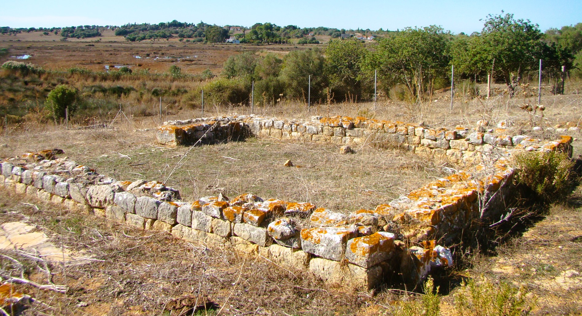
Abicada (Villa Romana de Abicada or Estação Romana da Quinta da Abicada) is the name of Roman ruins in Mexilhoeira Grande, to the north of the civil parish of Alvor, municipality of Portimão, in the Algarve region, Portugal. In Roman times it was in the colony of Ipses, in the Roman province of Lusitania, which was authorized to mint currency, and where a woman named Pompeia Exoce looked after the burial of her grandson. Portimão, east-southeast, known as Portus Magnus at the time, was an important Roman commercial port when the Roman villa was built.
The complex is located on a south-facing promontory spur located between Mexilhoeira Grande and Alvor. The spur lies about eight meters above sea level and is surrounded by the rivers Ribeira do Farelo and Ribeira de Senhora do Verde (Ribeira da Torre), which flow into the Ria de Alvor immediately south. The building, classified as a villa maritima, is characterized by its sophisticated architecture with two peristyles – one hexagonal and the other square-shaped. The villa contained well-preserved geometrically shaped polychrome mosaics (now in the museum of Portimão) and is believed to date from the 4th century AD. The hill itself was inhabited from the 1st to the 5th century AD and has supplied Roman artefacts from the 1st century to the 2nd century.
The villa and its wealth
The protected site is that of a villa rustica or agricultural facility consisting of a large (the villa covers an area of approx. 2000 m²) palatial residence the villa maritima or pars urbana, and a pars rustica or economic area. This building had a Mediterranean-style rigorously geometric architecture that related to the landscape – the attached portico (area D) opened to a view of the lagoon and the sea- and also to the mild climate to create an environment of architectural quality for its inhabitants. Mosaics, with floral and geometric compositions of diverse colors, covered the floors of the rooms. Since there was little agricultural area in the direct vicinity, the villa took its wealth from the nearby estuary.
In 1938 the archaeologist José Formosinho Sanches (1938) found the remains of the pars rustica including large basins which were used to process offshore seafood twenty meters south of the villa. A pier and dock allowed navigable access to the estuary and the sea. The high density of Post-Tartessos Iron Age sites in the area and the Copper age site of Alcalar indicates a settlement continuity of the indigenous population in the areas used in Roman times. The rich biodiversity of the estuary and lagoons explains this. Fish, shellfish, crabs, and once abundant birds sustained high human populations and in the 4th century allowed large-scale commercial exploitation.
The mosaics
Mosaic floors were found in almost all rooms in the areas A and B. On a layer of opus caementitium, magnificent patterns were laid from tesserae. The mosaics are polychrome and show geometric and floral patterns. But also vessels are depicted. The tesserae of different types of stone are in grey, red, white and blue.
Artifacts
The finds excavated in the 1930s are in the Museum Municipal Dr José Formosinho in Lagos. They consist mainly of metal artifacts such as lead and bronze objects. Due to the lack of stratification, the findings unfortunately do not give a meaningful overview. Later finds include tools of the fishing industry, cosmetics a glass plate with a collar edge (1st century AD) and few pieces of utility ceramics and amphorae dating to the middle imperial period and coins from later settlement phases, including two from the Constantinian period and coinage from the Theodosian period. The findings also included fish sauce garum and fish salting basins ( cetariae ) bordered with opus caementitium. This allows conclusions to be drawn on the marketing of maritime resources and underpins the classification as villa maritima.


Megalithic Monuments of Alcalar
37°11′56″ N; 8°35′17″ W
The Megalithic Monuments of Alcalar (Portuguese: Monumentos Megalíticos de Alcalar) are a group of burial tombs that comprise a Calcolithic necropolis, located in the civil parish of Mexilhoeira Grande, municipality of Portimão, Portugal.
History
During the 3rd millennium BC, a 10 hectare stretch of land, located at the end of a once navigable part of the Torre River became the centre of settlement. It was constructed on a hilltop along the Algarve's limestone coastal strip, in what became known as the settlement of Alcalar, approximately 5 kilometres (3.1 mi) from Mexilhoeira Grande.
Around 18 different megalithic tombs were constructed in the surrounding hills, forming a necropolis using various building techniques over time.
In 1975, the State partially acquired Tholos 7. The following year, a fence was constructed to protect the site.
In 1982, the State acquired the rural house called Courela das Minas and completed repairs to the fencing around the site.
During the 1990s, excavation of the monument and limestone sub-soils of Monte de Canelas was undertaken, resulting in the discovery that the space was used as an ossuary, where various rituals were completed, mostly in the deceased buried in the fetal position.
The site is located on a hilltop, with natural conditions that permit its defense.
The area is populated by a necropolis of various rectangular burial mounds and tholos (with chambers and corridors). Some include false copulas and lateral niches, with several architectural techniques employed in their construction.
Due to its monumental character, Tholos 7 (which was built in the third millennium) constitutes an undeniable histo-cultural and scientific center of the site, including its quantity of artifacts unearthed. The cairn beehive tomb is built from a mound of stones around a tholos, with an underlying corridor and vaulted chamber (or crypt). Its base consists of an entranceway schist and is duplicated in a wall the surrounds the structure, forming a pathway. Its diameter is 27 meters (89 ft), with an east-facing entrance-way located in the middle. Access to the main chamber is through the eastward-facing corridor, covered in large slabs of limestone that are oriented to narrowly focus access to the crypt. This space is covered by a slab of limestone and lies in the geometrical center of the tomb.


💓💓💓💓💓
SEARCH IN ALPHABETICAL ORDER
IN THE DISTRICT OF FARO

💓💓💓💓💓
Return to mainland Portugal &
the Azores and Madeira islands

