
FORTRESS OF SAGRES (FORTALEZA DE SAGRES)
37°0′2″N 8°56′54″W
The Fortress of Sagres (Fortaleza de Sagres) is a military structure, located near the Sagres freguesia, in the municipality of Vila do Bispo, in the Algarve region of Portugal. The fortress was built in the 15th century by order of Portugal's Infante Henry the Navigator. Heavily damaged in the 1755 Lisbon earthquake, it was rebuilt in the late 18th century albeit with significant remodeling. Inside, the Church of Nossa Senhora da Graça, also built by Henry the Navigator, stands out. The fortress is of great historical importance because of its connection to the history of Henry the Navigator and Portuguese discoveries. In 2018 it was the most visited monument in the Algarve, probably in the entire region south of the Tagus River.
Panoramic view of the fortress
Description
Site
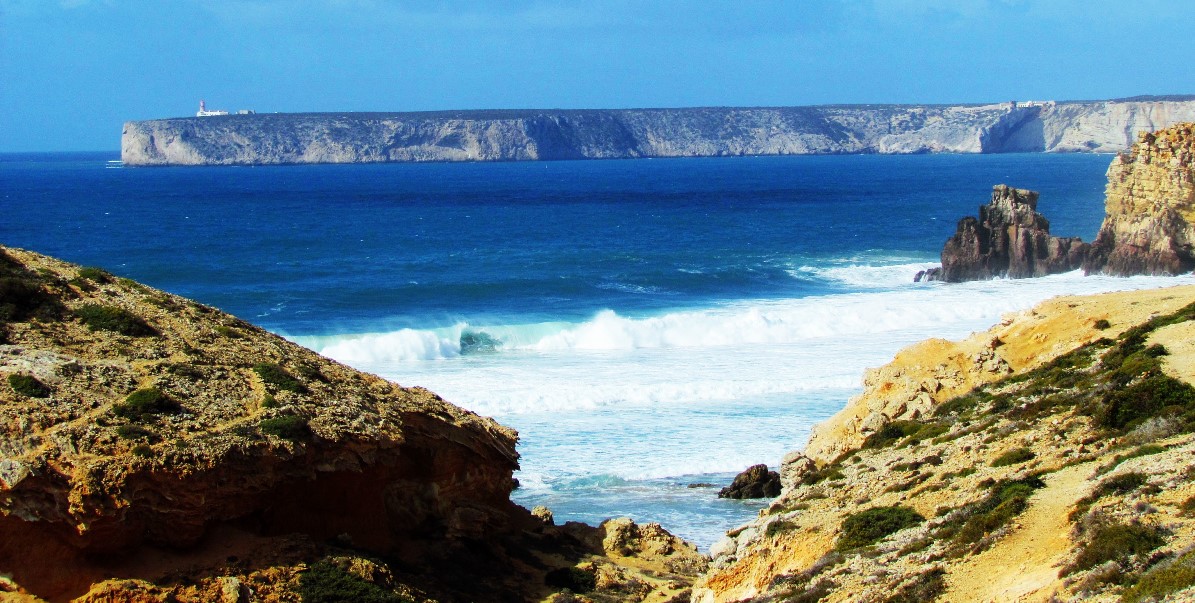
The fortress is located on a steep promontory to the east of Cape St. Vincent, about 1 km long, 300 m wide, and 40 m high, chosen as the site for the erection precisely because of its privileged position of control over the surrounding coastline. The area is now included in the Southwest Alentejo and Vicentine Coast Natural Park, known for its complex faunal and floral biodiversity, with unique specimens in the region.
Monumental walls and gates
The fortress features Renaissance-Mannerist architecture. The complex is basically polygonal in shape, comprising an enceinte and six batteries facing the ocean. The walls are surmounted by bastions on both sides and in the center had a turreted cavalier, facing inland, where the main gate of the fortress is situated. The structure bisects the promontory, precluding access except through the castle, whose side ramparts also served as a defense against inland aggression toward the fortress.
This layout, with the fortification closing the only entrance to a rocky promontory, jutting out over the coast or a waterway, is widely witnessed in southern Portugal: see, e.g., Paderne Castle and Arrifana Castle, also in the Algarve or the castles of Cola and Mértola, in the Alentejo.
In 1843, the cavalier's tower was about 50 palms (11.43 m) high and square in shape, with parapets forming a pentagon, garnished with cannons. In addition to these structures, the fortress also has several batteries and several wheeled cannons.
The neoclassical-style portal has wedges of carved stone masonry, with two padded stones, while the third one served as a plinth. The corners were changed during the restoration work, and their width was changed from 60 cm to 1 m. The portal leads into a tunnel that leads to the inner court, which is now covered with turf. This tunnel already existed in 1843, passing then under the repairs and the central tower, through a vaulted room. This room gave access to the interior of the fortress through a door, near which was also the entrance to the guardhouse, adjacent to the tower. In archaeological investigations, traces of a moat and a drawbridge were discovered at the entrance to the fortress.
Embankment and buildings
There were several buildings within the fortress, including a group called the "creek" that was adjacent to a wall on the south side of the place-of-arms. These buildings consisted of the House of the Cosmograph, the Governor's House and the House of the Infante. Later they were occupied by the House of Captains and several residences and chambers. Outside the place-of-arms, further south, was another property that was identified as a warehouse, and was later used as a stable, the ruins of which remain. There were also several warehouses, several batteries with cannons, and a cistern that is one of the few original remains of the Vila do Infante.
West of the church was a rectangular building with a hipped roof and a single slab on the main facade, with nine doors. The central building was square in shape and originally consisted of two main bodies, both on two floors, connected by a curtain wall. The main facade of the first body had no plinth and ended with a cornice and eaves, with three doors and two windows on the first floor and five windows on the second floor. The second body, to the east of the first, was known as the House of the Governor and was rectangular in shape, with the main facade also lacking a plinth and topped with a cornice, with two doors on the first floor and two windows on the upper floor.
The fortress also had an auditorium.
The fortress complex also includes a circular structure known as the "Rose of the Winds," discovered in the 17th century, which is believed to have been a sundial.
It is composed of several unequal-sized stones that form a radiating star with 32 directions. The "Rose" could be connected to a circular hermitage dedicated to St. Mary that would have been built at the behest of the Infante within the village.
To orient and inform visitors, several paths have been created with descriptive panels about the various parts of the monument, and plant and animal species on the promontory. A two-kilometer walkway was also installed for visitors with reduced mobility.
Church of Our Lady of Grace
Inside the fortress is the Church of Nossa Senhora da Graça, founded during the time of Henry the Navigator and originally dedicated to Saint Mary.
The building has a longitudinal, single-nave plan with a quadrangular apse, with the sacristy to the south in a similar shape. The interior of the nave is covered by a barrel vault, protected by a gable roof, while the chancel is surmounted by a dome on horns. The facades have no basement, the main one having two panes, one of which relates to the church building itself, where the entrance portal with an architrave is located, while the other corresponds to the belfry. The south facade also has two panes, one for the sacristy and the other for the church nave, with a window opening into the latter. The east-facing facade is the same as the south facade, also with a window, and includes a staircase for access to the bell tower.
Inside the church is a series of tombstones.
Preservation and importance
On January 31, 2017, the fortress was named a UNESCO World Heritage Site as part of the First Globalization Places list.
In 2018, the Fortress of Sagres was the most visited monument in the Algarve and probably in the area south of the Tagus River, having recorded nearly half a million visitors that year.
The area in which the fortress is located has played an important role from a spiritual point of view, because of its geographical location, far from population centers, and its shape, like a large promontory where the land enters the sea. The oldest references are due to the Greek historian Ephorus of Cyme (4th century B.C. ) who called it Hieron Akroterion, a name translated into Latin as Promontorium Sacrum ("Sacred Promontory") by Pliny the Elder in his Naturalis historia. Human occupation of the region dates back to at least the Early Neolithic, according to remains found at the archaeological site of Cabranosa, northwest of the village of Sagres. In Roman times, it is possible that it was a place of worship of the god Saturn or Hercules: several Roman remains have been found in the vicinity (Praia do Beliche, Ilhéus da Baleeira or Martinhal, and Praia da Baleeira). The area gained great importance from a spiritual point of view as the alleged burial place of St. Vincent after his martyrdom by the Roman official Dacian. During the Muslim period there may have been a building dedicated to the worship of that saint, described by the geographer Muhammad al-Idrisi as the Temple of the Raven. This temple would have been frequented mainly by Mozarabs, functioning until the 12th century, when the saint's mortal remains were transferred to Lisbon by order of King Afonso I of Portugal.
15th century
In 1438, Infante Henry the Navigator was in the Algarve region after his military defeat in Tangier the previous year, and he may have been interested in the Cape St. Vincent region at that time. Indeed, there is evidence that the Infante stayed several times in the town of Lagos, then the main port hub of Lusitanian exploration, and he may have used the stay to deepen his knowledge of the cape. It is therefore possible that at that time he matured the idea of creating a residence for himself in Sagres.
In the years that followed, Henry undertook to create his own land holdings in the Sagres region, and in 1961 historian Alberto Iria advanced a theory about the original location of the village founded by the Infante as his official residence. A site that would have consisted of several buildings surrounded by a wall, in the same place where the fortress of Sagres was later built. Several vestiges of the original masonry were later discovered at the site. The original complex, according to graphic sources left to us by Drake's Englishmen in the 16th century, had a central building with a small staircase and two visible fireplaces that was possibly the palace of the Infante. The Henrician community was not yet known as "Sagres," and the Infante himself called it Vila do Infante ("village of the Infante") or "my town of Terçanaball/Terçanaval," names that did not correspond exactly to the village but rather to the region in which it was located.
In 1459, the Infante moved to Barlavento Algarvio, where he remained until his death, and devoted himself there to, among other things, the development of his village of Terçanabal. At that time, the village was still considered an unpleasant place, although it experienced some growth in the 1450s, mainly due to the Infante's companions (e.g., the Venetian navigator Alvise Da Mosto had arrived there in 1454) and several people who were exiled there. Because of this population increase, the Infante had the parish of Santa Maria erected on October 14, 1459, "in a place once wild and then populated," which was handed over to the Order of Christ. The Infante died on November 13, 1460, in his village of Sagres.
After the death of Henry the Navigator, the city entered a period of decadence and changed administrators several times until the end of the reign of John II of Portugal in 1495. On October 29, 1471, King Afonso V gave the fiefdom of the city, up to Cape St. Vincent, to Rui de Sousa, while on June 22, 1487, an inhabitant of Raposeira, Rodrigo Anes, received the benefit of the captaincy of the village of Sagres. On April 1, 1495, he was granted the highest alcaidaria by King John II. In 1498, Rui de Sousa's son, João de Sousa, inherited the lordship of Sagres upon his father's death, later passing it on to his descendants, the Counts of Prado and the Marquises of Minas.
The fortress of Sagres was probably built in the 15th century to defend the Algarve coast, mainly the west coast, and the sea routes between the Atlantic Ocean and the Mediterranean Sea. It was considered the most important element of the coastal defense system, having two other nearby fortresses, Belixe and São Vicente, in support. It also served to defend the port of Sagres, involved not only in Portuguese exploration activity but also (and especially) an important hub of the Lusitanian fishing industry. The Church of Nossa Senhora da Graça was also built during the Henrician period.
Sagres school
According to tradition, in addition to the village, the Infante would also establish a navigation school in Sagres, the so-called "Sagres school." However, the Village of the Infante did not start functioning until around 1446, several years after the first major advances in African coastal navigation were made, such as the passage of Cape Bojador by Gil Eanes, which debunks the myth of the Sagres school. This tradition has been sensibly based on historical events, as the cape was one of the inspirations for the Infante to initiate African sailings, so Sagres can be said to have played a primordial role in the beginning of Portuguese discoveries. However, the existence of the Sagres school cannot be completely ruled out, although to be scaled down and/or relocated, for example to the nearby city of Lagos, the real center of sailings in Henry's time.
16th century
Initially Sagres was not a parish and the inhabitants had to travel to the distant village of Aldeia do Bispo for religious services. This inconvenience was solved with the founding of the parish on November 12, 1519 at the behest of King Manuel I of Portugal, who also ordered the construction of a parish church on the site. It was hoped that these measures would halt the gradual decline of Sagres, increasingly a pure site of military significance. On October 4, 1521, Rodrigo Anes' son Alexandre de Freitas received the ranks of captain and chief mayor of the city of Sagres. After his death in Azemmour, these functions were transferred to his brother Manuel de Freitas who took office on July 19, 1536 and was in turn replaced by Belchior Barreiros. Sagres had a small municipality that was later annexed to the one of Vila do Bispo, having at that time destroyed most of the documents and books of the former municipality.
In 1587, the English privateer Francis Drake made several raids along the Algarve coast: he sacked the village of Sagres and destroyed much of the fortress. The English, before the sacking, depicted the fortress, providing us with probably the oldest visual evidence of the fortification
17th and 18th centuries
In 1631, King Philip III of Portugal and Spain ordered the repair of some parts of the walls that had been knocked down, on the outer side of the fortress. According to historian Ataíde Oliveira, the fortresses of São Vicente and Sagres were subdued without resistance soon after the Restoration of Independence on December 1, 1640, which freed the country from Spanish rule. After 1640, an outer fortified structure was installed, following the system of the Count of Pagan. Also in the 17th century, the so-called "Rose of the Winds" was discovered.
The Sagres complex was severely damaged in the 1755 Lisbon earthquake that destroyed the original walls. Reconstruction work was only carried out starting in 1793, coordinated by José de Sande Vasconcelos, who followed a new model, bringing profound changes in the layout of the fortress. The work focused mainly on the Barracks, the "Governor's House," the building adjoining the cistern, the church, the military storehouses, and the outer wall. These works were commemorated on a plaque that was placed above the entrance to the fortress. According to archaeological investigations carried out in 2008 and records, the structures of the access tunnel and the central turret were built over about 24 years, in the transition from the 18th to the 19th century, although traces of earlier construction, probably from the old Henrician wall, remain on the north wall of the central turret.


👆👆👆👆👆
👆👆👆👆👆

SAGRES
N 37.00507º; W 8.94518º
Sagres is a civil parish in the municipality of Vila do Bispo, in the southern Algarve of Portugal. The population in 2011 was 1,909, in an area of 34.37 square kilometers (13.27 sq mi). It is historically connected to the early Portuguese Age of Discovery.
Sagres is near the Western end of the world's longest estimated straight-line path over land, at 11,241 km, ending near Jinjiang in the People’s Republic of China.
The area has been intrinsically linked to the nautical school first developed by Prince Henry the Navigator, which was installed in the 15th century.
In May 1587, explorer and privateer Francis Drake disembarked 800 men who assaulted the fortress of Sagres. After two hours of intense combat, fortifications adjacent to the fortress were destroyed and its artillery was pillaged.
Sagres is located in the extreme southwest of continental Europe and marked by two geomorphological structures: the Cape St. Vincent and Sagres Point, which establish a transition between the eastern coastal and meridional zones. Exposed to the Atlantic Ocean, it is influenced by Mediterranean currents, marked by promontories of high cliffs leading onto a platform that oscillates between 100–200 meters (330–660 ft) (in the north) and 50 meters (160 ft)). Whether by coastal erosion, or the hard rock, its composition influences the relief of the area.


💓💓💓💓💓
SEARCH IN ALPHABETICAL ORDER
IN THE DISTRICT OF FARO
💓💓💓💓💓
Return to mainland Portugal &
the Azores and Madeira islands

